| |
||||||
 |
 |
LOCAL | ||||
| |
||||||
 |
 |
 |
 |
|
 |
|
| Tynemouth Castle |
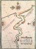
Tyne ~ Henry VIII |
Mouth of Tyne 1654 |
Trinity House 1723 |
Ralph Gardner River 1796 |
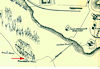
Wood's 1826 map |
Rook's 1827 map |
 |
 |
 |
 |
 |
 |
 |
| 1856 map | Blyth & Tyne 1863 |
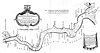
Tynemouth Station tile |
Tynemouth Dock story |
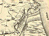
1875 with piers |
Tynemouthshire 1907 |
Reid's Map 1916 |
 |
 |
 |
|
|
 |
 |
|
N.S.
WW2 bombing |
Tynemouth 1949 |
Port of Tyne 1957(?) |
Tyne Walk 2011 by Birtley Aris |
Zoomable River Chart |
Tyne berths |
Pubcrawlers Guide |
|
COLLIERIES & WAGGONWAYS |
OLD MAPS ONLINE |
COMPARE MAPS SIDE BY SIDE |
UK RAILWAYS |
MAGIC MAPS (DEFRA) |
Alan H. Beautyman's Old Pub Maps |
TYNE SHIPWRECKS |
| Pictures of all these locations can be seen in the LOCAL HISTORY section | ||||||